

Parsons Blvd. is one of Queens’ lengthier roads, although NYC’s various traffic agencies and city planners haven’t shown it respect. It begins up north in Malba, a formerly private development in Whitestone in the shadow of the Bronx-Whitestone Bridge, and after an interruption by its approach road, the Whitestone Expressway, runs south and southeast through the heart of Flushing, but is stopped cold by Kissena Park, resuming again but with another interruption by the Horace Harding (Long Island) Expressway.
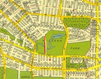
This 1949 Hagstrom map of Queens shows it continuing through Kissena Park, which may have been a dream of the Department of Traffic (later, “Transportation”) at the time. Little evidence except a park path exists that it was ever run through the park. This map also shows it stopping at 65th Ave. which was, at the time, the northern end of the Pomonok Country Club. Between the 1940s and the 196os, the country club was transformed into Electchester Housing, a project bringing middle-class digs to members of the International Brotherhood of Electrical Workers. Parsons Blvd. was extended through Electchester, and runs continuously from Booth Memorial Ave. south to Archer Ave. and the end of the E and J subway lines since 1988.
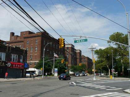
Parsons Blvd., 45th Ave. and 147th St. come together at General George J. Lawrence Square. Lawrence (1881-1949) practiced at Flushing Hospital, heading obstetrics and gynecology for many years. Lawrence served with the “Fighting 69th” Regiment during WWI, receiving two Silver Stars. He rose to Lieutenant Colonel at the end of the war and Brigadier General by World War II.
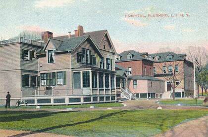
In my estimation, 60 percent of the local population finds itself in Flushing Hospital for one issue or another. I was younger and stronger when I lived a few blocks away from 1993-2007, and didn’t see many emergency rooms or hospital specialists, but was treated at Flushing Hospital for flu and received stitches. (And also got sticker shock for emergency room treatment before my Medicare eligibility.)
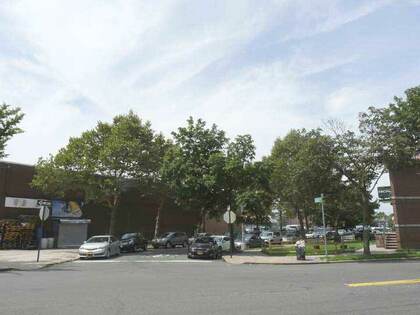
Historical information about Flushing Hospital is sketchy. It was founded in 1883 by “community-minded women” in Flushing “who set up a room with one bed in a rented house.” This postcard from the era on Forest, now 45th, Ave. presumably shows the house. The hospital expanded over the years to encompass a complex bounded by Parsons Blvd., Burling St., Delaware Ave. and 45th Ave.
When I first encountered Parsons Blvd. on Queens maps, I presumed it had something to do with area churches. However, the name reflects Flushing’s former status as an area whose commerce had much to do with commercial plant nurseries.
The park lies on the former plant nursery grounds of Samuel Bowne Parsons, and contains the last remnants of their plant businesses. Parsons Blvd. is the road built in the 1870s that connected Parsons’ farm with that of Robert Bowne. A natural body of water fed by springs connecting to the Flushing River was named Kissena by Parsons, and is likely the only Chippewa (a Michigan tribe) place name in New York State. Parsons, a Native-American enthusiast, used the Chippewa term for “cool water” or simply “it is cold.”
After Parsons died in 1906 the family sold the part of the plant nursery to NYC, which then developed Kissena Park, and the other part to developers Paris-MacDougal, which developed the area north of the park. Kissena Park attained its present size in 1927. Much of its southern end remains wilderness, with bridle paths running through it, although the local stables closed about 15 years ago.
Electchester is a housing project originally built for electrical union workers in the 1940s. The middle-income project was spearheaded by Harry Van Arsdale, Jr. president of Local 3 of the International Brotherhood of Electrical Workers. Another part was managed by the City Housing Authority who built the Pomonok Houses, among other developments. Electchester was the latest in a series of housing projects built for specific categories of unionized workers, joining the Amalgamated Houses, Bronx, and Seward Park Houses, Manhattan (garment workers); Concourse Village, Bronx (meat cutters); Big Six towers, Woodside (printers and lithographers).
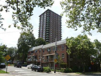
Electchester was constructed in stages from the late-1940s to the late-1960s, and the buildings in the project were named prosaically beginning with the First Houses and going up to the Fifth Houses, which are the two towers on 160th and 162nd Sts. Electchester has an unusual street layout with 160th, 161st and 162nd forming a rounded Y-shaped pattern between 65th Ave. and Jewel Avenue/Harry Van Arsdale, Jr. Ave.
Under Van Arsdale Jr’s stewardship Electchester built a community center and library. The Electric Industry Center featured a theater, bowling alley, a shopping center across the street, dental and medical units and a bar, and the Pomonok branch of Queens Public Library. Jewel Ave., arriving from Forest Hills to the west, was sub-named for Van Arsdale Jr. in 1988. The project sits on the former grounds of the Pomonok Country Club.
A curiously-named short street, Aguilar Ave., connects Kissena and Parsons Blvds. at 72nd Ave. This short path is shown on maps produced as early as 1852 and no doubt the road was there a long time before that. Kissena Blvd. and Parsons Blvd. were once part of the same road, the Jamaica Rd. to Flushing, and the “kink” that became Aguilar Ave. was there likely to get around a pond or swamp.
For years I was mystified about the Spanish-sounding Aguilar Ave.’s origins (the Spanish pronunciation is most likely Ah-GHEE-yar). Sergey Kadinsky, who helps me with my website Forgotten New York, says that the avenue, as well as Aguilar Library in East Harlem, was named for Grace Aguilar (1816-1847), a Sephardic Jewish educator, reformer, historian, and novelist, the most published Jewish woman of the 19th century. Aguilar Ave. runs past a number of housing projects that remain heavily Jewish.
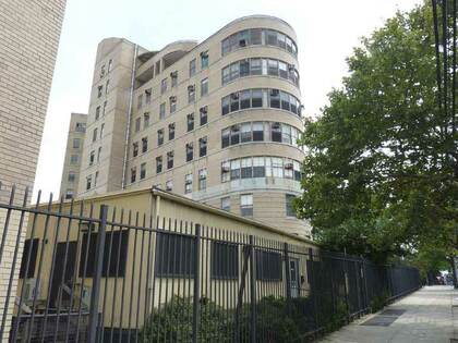
This round-ended building on Parsons Blvd. south of Union Turnpike is the “T building” of Queens Hospital Center (nee Queens General Hospital) and was originally known as Triboro Hospital, a tuberculosis treatment facility, built c. 1939-1940. With its airy wings and sun-drenched balconies, it was intended for the then-favored treatment of tuberculosis, plenty of fresh air and light. It’s similar in architecture to city hospital pavilions constructed on Welfare Island, the old Goldwater Hospital and North Brother Island (Riverside Hospital), now both demolished or in ruins.
Parsons Blvd. reaches its southern end in a thicket of churches. The Presentation of the Blessed Virgin Mary Roman Catholic Church at Parsons Blvd. and 89th Ave., built in 1922, features some extraordinary entablatures above its secondary entrances depicting the three members of the Holy Trinity. The congregation was organized in 1886, and the first church on the site constructed in 1894. The bell tower was shrouded in construction netting when I visited, but the rehab was completed by the fall.
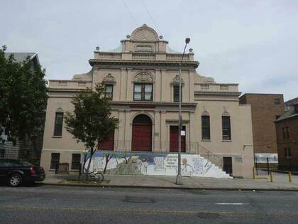
The lavishly baroque building parish hall is cornerstoned 1909. The church is named for an incident not recounted in the accepted Gospels, but in the apocryphal Infancy Narrative of James. Mary’s parents, Joachim and Anne, received a heavenly message that their daughter would be the mother of God and subsequently “presented” her at the Temple in Jerusalem for consecration.
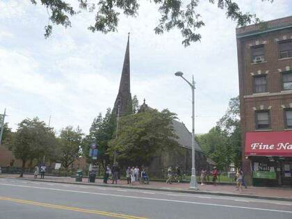
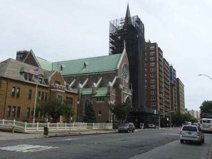
Grace Church and its churchyard face Jamaica Ave. and stretch around the corner to Parsons Blvd. This high-steepled church on Jamaica Ave. off Parsons Blvd. dates to 1862, replacing an earlier edifice dating to 1822 that burned the year before. The parish itself goes back to 1702 and the surrounding churchyard to 1734. US Senator and Presidential candidate Rufus King, whose mansion still stands next door on Jamaica Ave., and his descendants were enthusiastic parishioners. His son, NY State Governor John King, contributed a marble baptismal font to the old church in 1847 and an organ to the new church in 1862; later, the family provided an Oxford Bible, four prayer books and a bishop’s chair.
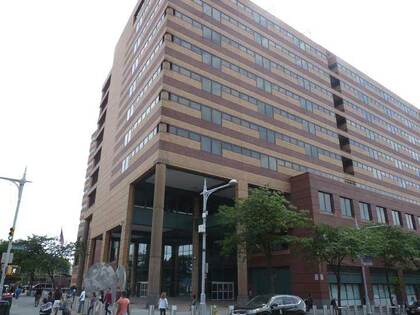
The Joseph P. Addabbo Federal Social Security Administration Building, completed in 1988 (the same year the nearby Archer Avenue subway line finally replaced the Jamaica Avenue El after 11 years). With its alternate brown shading, which reflects the sun nicely, it isn’t the Ministry of Love that some federal buildings occasionally resemble.
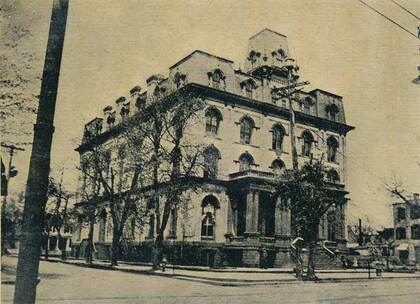
The Addabbo Administration building stands in opposite the spot once occupied by the Second Empire Victorian-era Jamaica Town Hall, which was built in the same era as the still-standing Flushing Town Hall and largely resembled it. Queens once consisted of a number of separate towns: Long Island City, Newtown, Flushing, Jamaica, Hempstead, North Hempstead and Oyster Bay. Queens’ western towns were dissolved when Queens joined NYC in 1898, while the three eastern were retained when Nassau became a country separate from Queens in 1899.
—Kevin Walsh is the webmaster of the award-winning website Forgotten NY, and the author of the books Forgotten New York (HarperCollins, 2006) and also, with the Greater Astoria Historical Society, Forgotten Queens (Arcadia, 2013)