

Yznaga Pl. is possibly the only place name in the United States that begins with “yz.” I’ve looked at USA and world atlases and can’t find anymore initial Yz’s. Yznaga Pl., at the south end of Brush Ave. near the Whitestone Bridge and Ferry Point Park, is one of those streets you see on the map, and say, “Do they really call it that?” and then forget about it. Yznaga, pronounced Is-naga, is a respectable Spanish name and there are, or were, a number of Yznagas in Cuba, and it’s there we discover the origin of this unusual street name.
The late Bronx historian John McNamara proposed three possibilities: “Yznaga Place was first mapped in 1898, during the Spanish-American War. It’s possible an American sailor spotted the Yznaga Brothers’ sugar plantation in Cienfuegos, Cuba, with its large ‘YZNAGA’ sign; the short street could be named for freedom fighter Jose Yznaga, who was inspired by Bolivar to raise an army of liberation against the Spanish…when his effort was unsuccessful, he exiled himself in New York; or for Fernando Yznaga, a friend of the Havemeyers, who owned much of the land in this part of the Bronx.”
The Yznagas (full name: Yznaga del Valle) were a rich, well-connected Cuban-American family who migrated to Natchez, Mississippi, before the Civil War. For a while they owned Dunleith, a grand Natchez architectural landmark. Later they moved to Paris, and then to New York, where the children of the family (including Fernando, mentioned in the text below) married well. A daughter, Maria Consuelo Yznaga del Valle, became the duchess of Manchester, and was known as Lady Mandeville.
The Yznaga Pl. street name in the Bronx possibly derives from the Yznaga’s friendship with the Vanderbilt family. It was Consuelo, Lady Mandeville, who introduced her Natchez friend, the poor but ambitious southern belle Alva Erskine Smith, to her future husband, the very rich William Kissam Vanderbilt. Lady Mandeville also helped launch the Vanderbilts into New York high society in 1883.
In gratitude, Alva named her daughter Consuelo (who later became duchess of Marlboro) after Lady Mandeville. As the Vanderbilts controlled most of the ferry and railroad connections around New York in the late-1800s, it would’ve been a gracious token of thanks to name a street after the family which had shown them so much kindness.
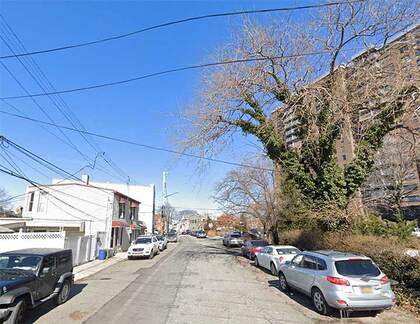
All that pedigree, and the Bronx’s Yznaga Pl. is a dead-end leading to a couple of decrepit shacks that were once respectable residences, with unused construction and earth-moving equipment lying around.
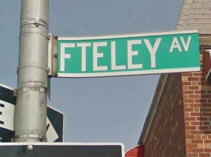
When I started poring over NYC street atlases in the 1970s, I was perplexed while fingering the Bronx Hagstrom because one of the streets in Soundview, just east of the Bronx River, was spelled Fteley. That had to be a misprint. No word begins with “FT.”
Typically, English doesn’t begin words with two consonants; the exception is with digraphs such as bl, br, ch, cr, dr, pr, pl, sl, st and more; these consonants’ sounds go together to produce one sound. Sometimes words will begin with two consonants that don’t jibe, such as cnidarian, bdellium, or pneumonia, but in cases like that the initial letter is usually silent.
After after looking at several maps, I ascertained this was no misprint and the name of the street was indeed spelled Fteley and found out it’s pretty much pronounced as spelled, “fa-TEL-lee.” I’d bet that no other place name in the world, begins with “ft” without a vowel separating the two consonants.
It turns out the explanation for the name is unique. There are groups of streets in Brooklyn named for the signers of the Declaration of Independence, NYC mayors in the NE Bronx, and classical composers and astronauts in Staten Island. In Soundview, the streets are named for civil engineers. According to John McNamara in History in Asphalt, Alphonse Fteley (1837–1903) was chief designer of the upstate New Croton Dam, which helps supply NYC with its drinking water. Fteley was a French immigrant and is buried in Woodlawn Cemetery.
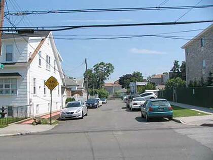
While skulking through Pelham Bay in the Bronx some years ago, I pondered the origin of the heretofore mysterious B St., which runs south to a dead end on Baisley Ave. between Hobart and Edison. Thanks to the efforts of Forgotten NY Fan Mike Fornebaio the “mystery” has been solved. This is one of the oldest streets in the area that kept its original name, and is one of the keys that unlocks the secrets of this unheralded realm.
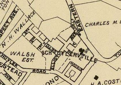
Notice the center of this 1900 map and an area called Schuylerville. Though the name’s now applied to the entire area within the triangle formed by the Cross Bronx Expressway, the Bruckner Expressway and the Throgs Neck Expressway, it was formerly applied to a much smaller area near the angle in the L made by Eastern Blvd., bow called Bruckner Blvd.
Hobart Ave. was formerly A St., which makes the presence of a B St. more logical. You can see both here on our 1900 map. Elliott Ave. is now Baisley; Fort Schuyler Rd. is now East Tremont Ave.; the roads marked Seton and Haskin have disappeared off the map. According to Bronx historian John McNamara, A St. went through a period as Amsterdam Ave. before becoming a dead-end extension of Hobart Ave., which otherwise runs between Baisley and Zulette Aves. and further north, between Middletown Rd. and Continental Ave. A numbered sequence, 1st, 2nd and 3rd, are long gone. B St. and the former A are survivors of old Schuylerville and Bronx veterans.
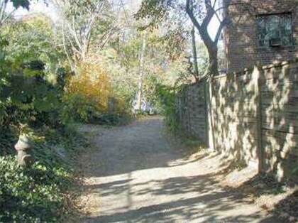
One of the oldest roads in New York State, the Old Albany Post Rd. is the former route used in the colonial era to bring mail from New York City north to Albany, hence its name. This is a one-block dirt road remnant of the ancient track. The remnant, which is unmarked by the Department of Transportation (yet lit by streetlamps), runs between W. 251st St. and Lakeview Pl. just west of Broadway.
In the 19th century, the Old Albany Post Rd. would be straightened and become the roads we know as Post Rd., and the much longer Rt. 9, which encompasses Broadway in NYC and further north, known as the Albany Post Rd. Route 9 goes to the Canadian border. A much longer 6.6-mile dirt remnant of the OAPR remains in upstate Putnam County.
Libby Pl., like the Old Albany Post Rd., it is a short remnant of a much longer road. The Pelham Rd. ran from Westchester Creek (just east of the small town of Westchester which became the area surrounding the present Westchester Square) northeast to the town of Pelham. It ran on the routes of present-day Hutchinson River Parkway, Libby Pl., Buhre Ave., Westchester Ave. and Shore Rd.
It ran through Middletown (so named, perhaps, because it was midway from the village of Westchester to the Pelham Bridge) and old Stinardtown, much of which is now Pelham Bay Park. Libby Pl. is possibly named for Elizabeth Cornell, a former landowner in the area. It was officially named in 1934.
—Kevin Walsh is the webmaster of the award-winning website Forgotten NY, and the author of the books Forgotten New York (HarperCollins, 2006) and also, with the Greater Astoria Historical Society, Forgotten Queens (Arcadia, 2013)