

Even though I grew up just blocks away from Dyker Beach Golf Course in Dyker Heights, I’ve never swung a golf club in my life. Who can afford golf clubs? And anyway, golf seems like a frustrating game if you’re not good at it—you have to chase a little white ball in a vast field. How do you find the ball after you hit it?
There was a soldier named Earl Woods stationed at nearby Fort Hamilton in the 1960s; he learned the game here and passed his knowledge to his son, Tiger. I did take an interest in Dyker Beach Golf Course—I bicycled past it frequently both on 86th St. and on 7th Ave. on the way to Veterans Hospital and the then-unnamed road, lately called Poly Place on street signs, that went to Bath Beach. There was, however, another unnamed road that went unnamed until recently. Both these unnamed streets were affronts to my well-ordered brain then.
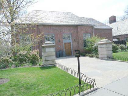
It’s a crescent-shaped road that runs through the greensward between 7th Ave. and 86th St., paved with concrete blocks (other area roads are blacktopped). The road provides auto access to DBGC’s handsome brick pro shop and clubhouse buildings. The green area between the drive and 7th Ave./86th St. is a public green space and has been used as a dog run.
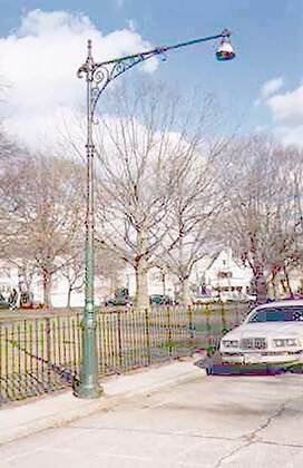
My interest in bicycling this drive as a kid, and into adulthood, was that it harbored 4 or 5 Type G “Corvington” lampposts, that gradually deteriorated through the years. They’d been equipped with “Gumball” luminaires but gradually the reflector bowls fell off and the lightbulbs weren’t replaced. Amazingly, though, they survived till about 1999 or 2000, when they were finally torn down, but not till after I got a couple of shots.
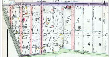
Dyker Beach Golf Course didn’t assume its current acreage until 1935, and early in the 20th century a passel of short streets emanated south from 86th St. between 7th and 14th Aves. There were Gubner, DeRussy (misspelled on the map), Morrison, Delaplaine, 10th, 11th, 12th and 13th Aves., as well as the sequence beginning with Bay 1st, Bay 2nd, etc. All of these were later swallowed up by the golf course, but some had been paved in 1917, when this map was made. (That’s why the numbered Bay streets in Bath Beach begin with Bay 7th; the others had been eaten by DBGC.)
The DeRussy referred to here was General Rene Edward DeRussy (1789-1865), an “engineer, military educator, and career United States Army officer who was responsible for erecting many Eastern United States coastal fortifications. He served as superintendent of the United States Military Academy and was promoted to brigadier general during the American Civil War,” according to Wikipedia. DeRussy helped design and build Fort Hamilton in 1825, which is likely why he was remembered by a street name here, and forts throughout the nation.
DeRussy lived on a hill in what became Dyker Heights, and also supervised the construction of the New Utrecht reformed Church, on 18th Ave. and 83rd St., in 1826. Later, he moved to California and designed several forts in the San Francisco area. He’s buried at West Point.
Dyker Beach Park and Golf Course evolved in stages from its beginnings in 1895 and 1935. The small streets shown on the map were likely condemned by 1927 and the park extended over them to 86th St.
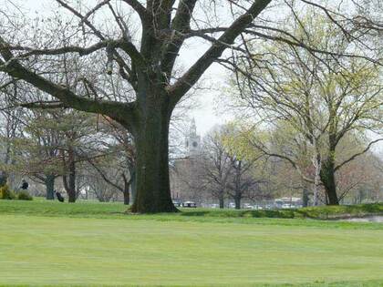
Glancing across the golf course from 86th St. provides a view of the four-sided clock tower of Poly Prep Country Day School, if you know where to look. Poly Prep Country Day School has had its distinctive Georgian campus on 7th Ave. and 92nd St. since 1916. Its four-sided clock tower is a Bay Ridge landmark and can be seen from most points in the Fort Hamilton area. Other than the occasional chicken scratching in a front yard (Bay Ridge still held on to shards of its former rurality when I was a kid) the only chickens or ducks I ever saw outside of a petting zoo were in the Poly Prep grounds on 92nd St. Sadly, the fowl were relocated a few years ago.
Though there’s a Parrott Place and a Poly Place in Bay Ridge, neither have anything to do with the birds with the big claws and beaks—Poly Place is named for Poly Prep. The wedding cake-white, four-sided clock tower of what used to be called the Polytechnic Institute but is now Poly Prep Country Day School on 7th Ave. between 92nd St. and Poly Place can be seen from Bay Ridge and Dyker Heights. Poly Prep, a private school for students from kindergarten through high school, was instituted on downtown Livingston Street in 1854 and was offered the present plot by Dyker Meadow Golf Club. In 1916, the school became the Poly Prep Country Day School, and the familiar clock tower, visible from all over southern Bay Ridge, was completed in 1917. Poly became fully co-ed in 1979.
—Kevin Walsh is the webmaster of the award-winning website Forgotten NY, and the author of the books Forgotten New York (HarperCollins, 2006) and also, with the Greater Astoria Historical Society, Forgotten Queens (Arcadia, 2013)