

To arrive at St. Andrews’s Church in Richmondtown, Staten Island takes persistence, since you have to make your way across one of the more pedestrian-unfriendly crossings in New York City. The stoplights at the T intersection at Richmond Hill and Arthur Kill Rds. are calibrated to permit traffic movement along three major routes, and while there’s a control, it rarely shows green for pedestrians, who aren’t deemed important here. In addition, the roads are sidewalk-free with no shoulders. (I realize the City has become more bike-friendly, though not as pedestrian-friendly, in recent years, and it’s odd that the Department of Transportation has dropped the ball, though I realize it’s Staten Island we’re talking about where the auto remains unchallenged for its crown.)
You then cross a stone bridge taking Richmond Hill Rd. across narrow Richmond Creek, built in 1845 and billed as Staten Island’s oldest arch bridge, though I may have found one just as old.
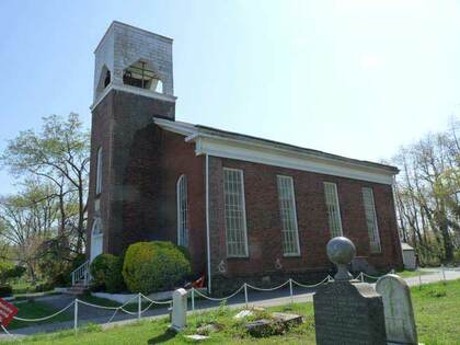
The Episcopal Church of St. Andrew was granted a charter by the British Queen Anne in 1712 after its inception three years earlier; that charter remains in the church’s possession today. The church barracked British troops during the Revolutionary War, and traces of their fortifications can be detected on Fort Hill to the rear of the church. The present church is a Romanesque structure built in 1872.
The churchyard contains dozens of stones dating back to the early-1700s, recognizable by the winged angel carvings at their tops. Family members of Mother Elizabeth Bayley Seton, America’s first canonized saint (in 1975) are interred here, as well as familiar names from Staten Island street maps.

Further along Richmond Hill Rd., Old Mill Rd. comes into view. The road’s now a dead-end to traffic, originating just south of Richmond Hill Rd.’s S-shaped “Snake Hill” curve—it mainly leads to the church caretaker’s building. However, it’s a very old road that may go back to the colonial era. Its route included a former British fort from the Revolutionary days, and a tidal grist mill from which Old Mill Rd. gets its name, in operation from 1790-1927. Before Latourette Park, through which the road now runs, was created, this land was in the possession of several landholders including the Green family. The condition of the park is now a far cry from what it was in the 1970s, when Staten Islanders hauled wrecked cars up here and used it as a junkyard.

After continuing north on Richmond Hill Road, called “Snake Hill” by locals because of its twisting nature, you arrive at Decker Farm. The Decker family has roots in Staten Island that trace to the beginnings of Dutch colonization in the 1600s, and Deckers can be found in every Staten Island cemetery. One of the Decker farms in what’s now Heartland Village, at 435 Richmond Hill Rd., is one of New York City’s two farm museums (the other’s the Queens Farm Museum in Glen Oaks). On Decker’s 20 acres, immigrant farmers are trained to grow native crops in NYC’s northern climate as part of the New Farmer Development Program.
The Decker Farm’s open to the public: visitors can learn about farm life with hands-on activities such as rug beating, hay raking and apple and pumpkin-picking in the fall.
The acreage has been used as a farm since 1809. The farmhouse, owned and operated by the Staten Island Preservation Society, was built by Japhet and Sarah Alston that year; the property was sold to Lorenzo Decker in 1841, and the Decker family farmed and lived here until 1955, when Alberta Decker donated the property to the Staten Island Historical Society.

After passing the Decker, Richmond Hill Rd. enters a part of Staten Island called Heartland Village, a development near the center of Staten Island begun in the late-1960s and completed in the 1980s, built concomitantly with the development of the Staten Island Mall.
Heartland Village uses several street naming themes. There’s an Alaskan theme, with Alaska Place and Yukon, Nome, Platinum (which is mined in Alaska) and Klondike Aves. The mapmakers probably considered this area so remote that it might as well be in Alaska. There’s also a college theme, with Purdue, Vassar, Rockne, Villanova, and Marymount (spelled Merrymount here). And a New England theme: Bowdoin, Copley, Bangor. I like this it beats the usual Mulberry, Spruce, and plant names scheme.

Most notable is the street-naming system using the names of astronauts from the Mercury, Gemini and Apollo space programs of the 1960s. The theme includes James McDivitt, James Lovell (the commander of the Apollo 13 mission that broke down en route to the moon), Wally Shirra, Frank Borman, Deke Slayton, Pete Conrad (the third man on the moon), John Glenn (the first American to orbit the Earth in space), Scott Carpenter, Alan Shepard (the fifth man on the moon), Gordon Cooper, and Gus Grissom.

Richmond Ave. has, from the earliest days of European habitation, been the major north-south route in mid-Staten Island, stretching from the Kill Van Kull in Port Richmond to the Atlantic Ocean in Great Kills, the only Staten Island route to do so. It’s one of the busiest streets in New York especially since the Staten Island Mall was opened in the 1970s and engineers added lanes to it between Forest Ave. and the Korean War Veterans, or Richmond, Parkway. Here at this bus stop several lines running to both Port Richmond and St. George can be accessed.
On Richmond Ave. south of Victory Blvd., The Asbury Methodist Church’s walls are as old as 1849, with the interior remodeled in 1878. The church was named for Bishop Francis Asbury (1745-1816), an itinerant preacher who became America’s first Methodist Episcopal bishop. It’s now Son Rise Charismatic Interfaith Church. An even earlier church called the North End Church once stood on this site.

The historic church is surrounded on three sides by a cemetery, whose first interments were in 1804. Different sections of the cemetery are in various states of upkeep or down-keep. To visit its most famous resident, enter through this gate, walk straight ahead to the back of the graveyard, and turn left. Before you is the gravesite of Col. Ichabod Crane, a military man who was an acquaintance of author Washington Irving. He’s buried here with his wife and brother as well as Juan, a Native-American boy who accompanied Crane after he was stationed in Oregon. Crane later learned (to his horror, by all accounts) that the protagonist of Irving’s famed 1820 story “The Legend of Sleepy Hollow” bore his name.
Repeatedly vandalized over the years, the Crane grave marker was restored in 2004 by the Joseph G. Hall and Sons Monument Company of Pleasant Plains, Staten Island. Col. Crane’s house stood nearby in New Springville until the 1980s, when it was torn down and a warehouse built in its place. There’s a street near the cemetery called Sleepy Hollow Rd.

After zigzagging around the streets north of the cemetery, I found Signs Rd., which runs between Richmond Ave. and Victory. This is another longstanding Staten Island street name that’s a complete mystery to me—you might guess there were a number of signs along the route, but signs pointing to what?
There are other strangely-named roads on the island: Fingerboard Rd., in Clifton and Grasmere, is said to have been named for a large finger-shaped directional sign positioned on the road directing the way to the Richmond County Courthouse, then located in Richmondtown. Older maps in Willowbrook mention a Skunks Misery Rd. Sunset Ave. in the same neighborhood used to be called Gun Factory Rd.

Victory Blvd., which runs from the St. George Ferry area to the Arthur Kill (where there was originally a ferry to New Jersey), was built as a toll road in the 1810s by a consortium led by Vice President Daniel Tompkins. By the end of World War I it had lost its tolled status but was still called Richmond Turnpike; it was renamed in honor of the American effort in World War I in 1918.
I’ve now stumbled into Bulls’ Head, which is named for a vanished Revolutionary War-era tavern at what is now Richmond Ave. near Victory Blvd., which had a large sign featuring the titular bovine. The tavern was a meeting place for British troops and other Tory residents of the area.
—Kevin Walsh is the webmaster of the award-winning website Forgotten NY, and the author of the books Forgotten New York (HarperCollins, 2006) and also, with the Greater Astoria Historical Society, Forgotten Queens (Arcadia, 2013)