
On one of the hottest days of the year, I traveled to Far Rockaway. The plan was simple. I’d take the A train—which runs through Brooklyn Heights, downtown, Fort Greene, Bedford-Stuyvesant and East New York through the heart of Brooklyn and Woodhaven, Queens and across Jamaica Bay—and take it to its farthest limit: the Mott Ave. station in Far Rockaway. There are many things to see from an infrastructural and historical perspective: commercial buildings, a Monticello-inspired post office, churches, lovely homes, and more.
Here, the general grid system that dictates the street layouts of most NYC neighborhoods falls away, and like downtown Boston, it’s more like a hub, with the spokes circulating around the intersection of Mott and Cornaga Aves. Though there are regulation four-cornered intersections, even that disappears in Wavecrest, originally a private development built around 1900.
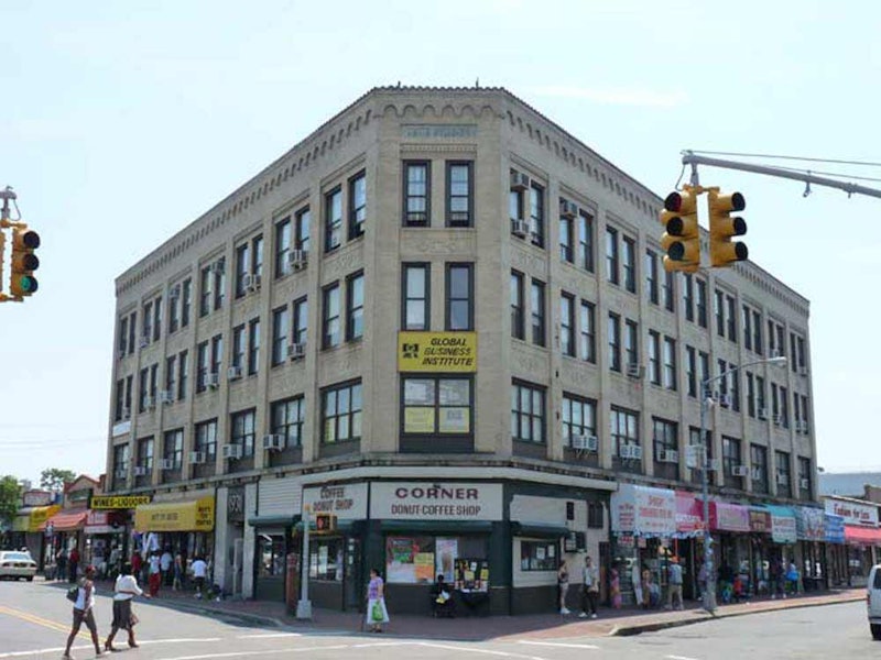
Above is seen the Smith Building, which occupies the NE corner of Mott and Central Aves., the two most prominent avenues in the neighborhood. The building dates to 1931 and replaced an earlier Smith Building that went up in 1911; it had contained offices of the Far Rockaway Bank, whose president was named Samuel R. Smith. There’s also a dead-end Smith Ct. in the back of the building facing Mott Ave.
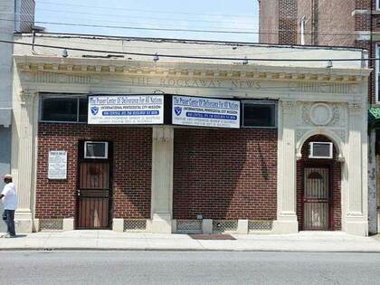
The former Rockaway News on Central Avenue is a distinctive little building. Since the Rockaways became a resort area in the late-1800s, there have been a series of newspapers published serving the community. The first was The Rockaway Rattler, later the Rockaway Journal, first published in 1883. It was followed by Rockaway Life, Far Rockaway Journal, The Argus, and The Rockaway News. The sole survivor is The Wave, founded in 1893. Tragically, The Wave lost much of its physical archives to Hurricane Sandy.
Turning up Mott Ave., named for landowner Benjamin Mott, who donated property for the original Long Island Rail Road terminal (which stood where the shopping mall across the street from the A train terminal on Mott Ave. is now). The US Post Office on Mott Ave. and Beach 18th St. was finished in 1936 and designed by architect Eric Kebbon. It was built in a Colonial Revival style and its dome inspired by Thomas Jefferson’s Monticello.
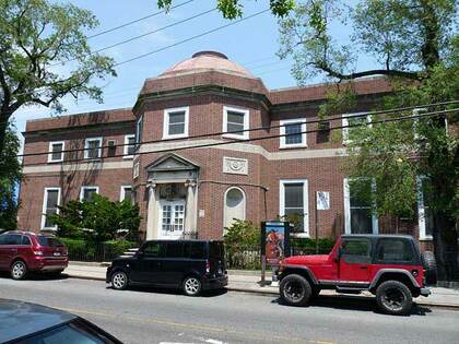
The oldest church in Far Rockaway, now the Beth-El Temple, can be found across Beach 18th from the post office on Mott Ave. It was built in 1858 to a design by ecclesiastical architect Richard Upjohn of Trinity Church fame. It was a chapel of the Trinity parish before it became the independent St. John’s Episcopal Church in 1881. It became the Beth-El Temple in 1975.
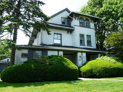
Mott Ave. ends at Caffrey Ave. on its east end. Continue on Caffrey and turn left on Beach 9th St., which was called Jarvis La. and Oak St. before 1916, when Far Rockaway acquired its “Beach Street” numbering system. It’s a main north-south thoroughfare in the eastern part of the town. Between Cornaga and Central Aves., it features a collection of freestanding houses built from 1890-1920 that can rival anything in Richmond Hill, Queens or Prospect Park South, Brooklyn.
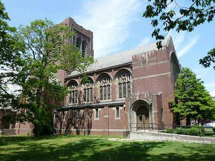
At the north end of Beach 9th St. at Central Ave. is the doyenne of Far Rockaway churches, the Russell Sage Memorial First Presbyterian Church. Financier and philanthropist Russell Sage (1815-1906) left a fortune to his widow Margaret Olivia Slocum Sage (1828-1918), who established the Russell Sage College for Women in Troy, NY. She established bird sanctuaries in Louisiana and founded NYC’s Russell Sage Foundation, dedicated to research in social welfare, public health, education, government, and law.
Mrs. Sage also funded this magnificent building, the First Presbyterian Church, a.k.a. The Sage Memorial Church, with its stained glass windows designed by Louis Comfort Tiffany. It was built in 1909 by the Cram, Goodhue and Ferguson firm.
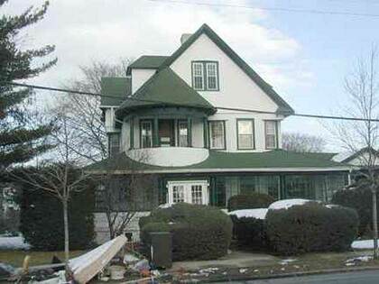
A mansion found along Mott Ave. in Bayswater. The neighborhood occupies the northwestern section of Far Rockaway along Norton Basin on the west and Mott Basin on the north. Bayswater was a planned community laid out by developer William Trist Bailey, who purchased the swampy territory from the Cornells in 1878. It was home to yacht clubs and, as you can see, attracted a wealthy crowd with aristocratic pretensions. British-style fox hunts were once held here.
Bayswater is one of those nearly-anonymous NYC neighborhoods. It’s tucked away far from Manhattan, and practically no mass transit intrudes here except the bus that goes up and down Mott Ave.
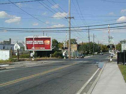
The Long Island Rail Road Inwood station is just a few feet away from Queens, although it’s situated in one of Nassau County’s Five Towns. Doughty Blvd. parallels the city line for a few blocks without entering NYC. There’s a grade crossing over the LIRR. The 20-year-old Nassau Expressway (US878) is out of the picture to the right. Once planned to stretch to Kennedy Airport, it was built piecemeal; the part of it in the Five Towns reaches only to Rockaway Turnpike, which changes its name to Boulevard once it reaches the NYC line at Meadowmere Park. To the west of Doughty Blvd., there’s the Redfern Houses on the avenue of the same name in Queens.
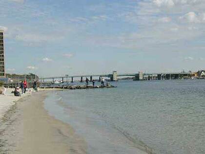
Reach the beach. In its salad days Far Rockaway was a resort town par excellence and had dozens of Victorian mansions (enough to rival those in today’s Cape May, NJ) built near the water’s edge, as well as casinos, parks and nightclubs. Today the waterside mansions and clubs are all gone, remembered only in street names like Ostend Ct., which recollects the old Ostend Hotel and Casino. In the center, there’s a view of the Atlantic Beach Bridge, opened in 1952. The bridge charged a five-cents toll for pedestrians and cyclists, (and a quarter for cars) until the 1970s, when the bridge was finally paid for.
What is “far; about Far Rockaway? I’d always guessed it was named for its distance from the rest of Queens, but it’s had this name from the start, even before it became a part of NYC beginning in 1898. It was named for its distance west from the older town of Near Rockaway (now called East Rockaway). Both towns were originally in Queens County, but Near Rockaway became a part of the new Nassau County when Queens’ three eastern counties decided to secede (without firing a shot) in 1898, the same year Queens became part of NYC.
—Kevin Walsh is the webmaster of the award-winning website Forgotten NY, and the author of the books Forgotten New York (HarperCollins, 2006) and also, with the Greater Astoria Historical Society, Forgotten Queens (Arcadia, 2013)